
Check progress before you drive.
Review the site as it looked on the capture date. Use it for routine updates and to prepare better questions for the next visit.

2D & 3D AERIAL MAPPING
An overhead image and dimensional visual context to help builders, developers, and owners understand a changing site.
Request a project quoteREAL WEMAD™ WORK · 2D SITE MAPPING
Think of a 2D orthomosaic as a detailed overhead photograph stitched into a map. Everyone can point to the same road, building, or work area—even when they are miles apart.
Explore WEMAD™’s Singapore Trail map, captured October 30, 2026. Zoom in to see the visible work, or switch layers to explore the site from another perspective.
EXPLORE OUR WORK · INTERACTIVE 2D MAP
Use + and − to zoom, drag to move, and open Layers to switch backgrounds or view the elevation layer. Original WEMAD™ mapping, hosted by Maps Made Easy.
Review the site as it looked on the capture date. Use it for routine updates and to prepare better questions for the next visit.
Show subcontractors the entrance, delivery route, staging space, or area being discussed. A shared view can make calls and project meetings clearer.
For an agreed measurement deliverable, review distances or areas—such as an access route or paving area—so contractors can price the same scope.
This public viewer offers zoom and layers. Measured quantities require accuracy checks appropriate to the job; discuss those requirements with WEMAD™ before capture.
Plan your site mappingAGREED BEFORE THE VISIT
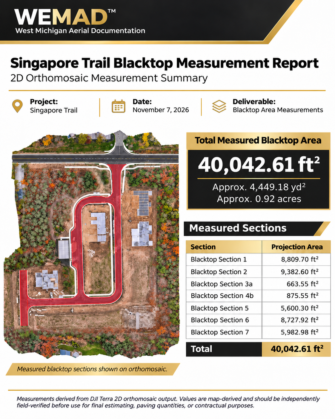
A 2D orthomosaic combines overlapping aerial photographs into one overhead image of the captured area. Builders, developers, and property owners can use it to discuss the relationship between structures, access, open areas, and other visible site features. It provides a shared visual reference for a project conversation and can help illustrate changes between capture dates. Tell us what area you need covered and which features matter most. We will discuss the appropriate output and any labelling requirements before the visit. At Singapore Trail, WEMAD™ used 2D orthomosaic measurements to document 40,042.61 square feet of blacktop. Open the report above to see how much pavement each section contributes.
Where the site and capture conditions are suitable, photogrammetry can build a dimensional visual model from overlapping photographs. Viewing visible surfaces from different angles can help communicate the shape of a building, its surroundings, and how features relate to one another. Discuss the purpose and delivery format before choosing 3D coverage, including how you intend to view or share the result. Model detail depends on what the camera can capture; hidden or obstructed areas may be incomplete. The credited model shown on this page is an illustrative example of photogrammetry, not a WEMAD™ client deliverable.
Send the property location, approximate area, project stage, and the decision or update the imagery needs to support. Explain whether you need a visual overview, repeat documentation, or particular measurements so the capture and processing scope can be discussed first. Accuracy requirements and any surveying or engineering needs must be agreed before work begins; visual mapping should not be used to establish legal property boundaries. We will confirm suitable access, flight conditions, output formats, and the quoted deliverables. For a changing site, repeat capture dates can be coordinated with construction progress visits.
YOUR PROPERTY. YOUR PROGRESS. YOUR PERSPECTIVE.